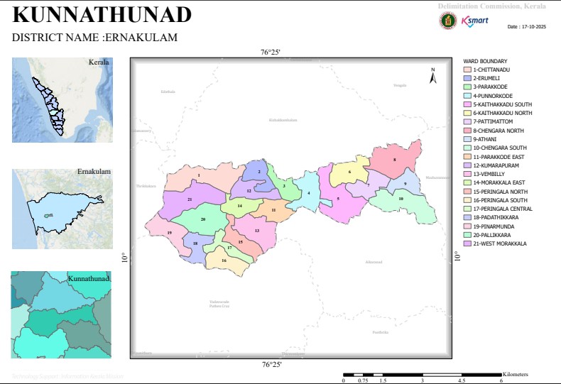

Map
Kunnathunadu Grama Panchayat Ward Division – Analysis Report
Summary of Report
As per the final order issued by the Kerala Delimitation Commission on 15th May 2025, Kunnathunadu Grama Panchayat in Ernakulam district has been divided into 21 electoral wards (constituencies). This ward re-division was implemented after the number of members to be directly elected in the Panchayat elections was fixed at 21.
Key Information
Panchayat: Kunnathunadu Grama Panchayat
District: Ernakulam
Total Wards: 21
Date of Order Issued: 15-05-2025
Purpose: Ward delimitation for Panchayat elections and ensuring population balance.
List of wards and population
Ward name
Population
1: Chittanad-1,453
2: Erumeli- 1,569
3: Parakode-1,518
4 : Punnarkkad-1,586
5: Kethakad South- 1,710
6: Kethakad North-1,712
7: Pattimattom-1,748
8: Chengara North-1,557
9: Athani-1,407
10: Chengara South-1,460
11: Parakode East-1,715
12: Kumarapuram-1,564
13: Vempilly-1,652
14: Morakkala East-1,443
15: Peringala North-1,610
16: Peringala South-1,516
17: Peringala Central-1,659
18: Patathikkara-1,739
19: Pinarmunda-1,741
20: Pallikara-1,480
21: Morakkala West-1,668
Demographic Analysis
Wards with the highest population
Pattimattom – 1,748
Pinarmunda – 1,741
Patathikkara – 1,739
Parakode East – 1,715
Kethakad North – 1,712
Wards with the lowest population
Athani – 1,407
Morakkala East – 1,443
Chittanad – 1,453
Chengara South – 1,460
Pallikara – 1,480
Observation
The population of the wards is in the range of approximately 1,400 to 1,750.
Since the population difference is very small, there is no major imbalance in representation between the wards.
The division has been done in such a way that each ward gets approximately equal importance in the electoral process.
Geographical Observations
The report has determined the ward boundaries mainly based on the following factors:
Main roads (Pattimattom–Muvattupuzha road, Erumeli–Pangode road, etc.)
Streams, canals, rivers
Nearby grama panchayat boundaries
Local landmarks such as colonies, churches, schools, farm roads
This helps in clearly defining the physical and administrative boundaries.
Potential impact of major changes
Political impact
The new ward boundaries may influence the election results.
There may be a change in the local political equations as some areas have been shifted to new wards.
Administrative benefits
Balanced distribution of population.
Efficient implementation of development projects.
Easier delivery of ward-based services.
Regional development
Equivalent resource utilization will be possible for each ward.
More accurate planning for infrastructure development will be possible.
Conclusion
The re-division of Kunnathunadu Grama Panchayat into 21 wards is aimed at population balance and administrative efficiency. Since the population difference between the wards is very small, this is a ward structure that ensures balanced local governance and fair representation of the people. The new boundaries will serve as a baseline for Panchayat elections and future development activities.